Our mission is to help computational modelers develop, document, and share their computational models in accordance with community standards and good open science and software engineering practices. Model authors can publish their model source code in the Computational Model Library with narrative documentation as well as metadata that supports open science and emerging norms that facilitate software citation, computational reproducibility / frictionless reuse, and interoperability. Model authors can also request private peer review of their computational models. Models that pass peer review receive a DOI once published.
All users of models published in the library must cite model authors when they use and benefit from their code.
Please check out our model publishing tutorial and feel free to contact us if you have any questions or concerns about publishing your model(s) in the Computational Model Library.
Displaying 10 of 393 results for "Tim Gooding" clear search
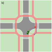
Agent-based Line-of-Sight Simulation for safer Crossings (Short Paper - Netlogo Model)
Vincent Franke | Published Thursday, August 05, 2021This software simulates cars and bicycles as traffic participants while crossing different crossroad designs such as roundabouts, protected crossroads and standard crossroads. It is written in Netlogo 6.2 and aims to identify safety characteristics of these layouts using agent-based modeling. Participants track the line of sight to each other and print them as an output alongside with the adjacent destination, used layout, count of collisions/cars/bicycles and time.
Detailed information can be found within the info tab of the program itself.
Demographic microsimulation for individuals and couples
Sabine Zinn | Published Wednesday, January 14, 2015The simulation model conducts fine-grained population projection by specifying life course dynamics of individuals and couples by means of traditional demographic microsimulation and by using agent-based modeling for mate matching.
(De-)Stabilising effect of diffusions
Julia Kasmire Bert Van Meeuwen Cornelis Eikelboom | Published Tuesday, August 11, 2015What is stable: the large but coordinated change during a diffusion or the small but constant and uncoordinated changes during a dynamic equilibrium? This agent-based model of a diffusion creates output that reveal insights for system stability.
Exploring the aftermath of transition failures: An agent-based model
Gangmin Park Junmin Lee Jisoo Lee Keungoui Kim | Published Friday, March 06, 2026This computational model is an agent-based model (ABM) developed to investigate how repeated failures of emerging niches accumulate and influence the trajectory of socio-technical transitions. Built in AnyLogic 8.7.11, the model simulates the dynamic interactions between a dominant regime and sequential niche entrants within a two-dimensional practice space. It models alignment, movement, and competition based on technological maturity and market penetration. The model utilizes a reinforcing feedback structure linking consumer support, output, resource accumulation, and capacity development (Physical and Institutional Capacity). A complete model specification following the ODD+D (Overview, Design concepts, Details, and Decision) protocol is included in the documentation.
Learning-based Protection Motivation Theory Climate-Adaptive Behaviour model (LPMT-CAB)
Wenhan Feng | Published Thursday, April 09, 2026The aim of this model is to study the dynamic propagation of individual climate adaptive behaviours in different scenarios within the analytical framework of conservation motivation theory, focusing on the impact of social and experiential learning on the adoption of climate adaptive behaviours by coastal farmers.
Model for paper “Promoting climate resilience through learning-based behavioural change: Insights from an agent-based model of a coastal farming community in Guangxi, China” in Environmental Science & Policy, Volume 179, May 2026, 104375, https://doi.org/10.1016/j.envsci.2026.104375
A Mathematical Model of The Beer Game
Hakan Yasarcan Mert Edali | Published Wednesday, November 05, 2014This is the R code of the mathematical model that includes the decision making formulations for artificial agents. This code corresponds to equations 1-70 given in the paper “A Mathematical Model of The Beer Game”.
Tyche
Tony Lawson | Published Tuesday, February 28, 2012 | Last modified Saturday, April 27, 2013Demographic microsimulation model used in speed tests against LIAM 2.
Feedback Loop Example: Vegetation Patch Growth
James Millington | Published Thursday, December 20, 2012 | Last modified Saturday, April 27, 2013This model illustrates a positive ‘growth’ feedback loop in which the areal extent of an entity increases through time.
Peer reviewed ELTAP-Egy model (Energy Landscape Transition Analysis and Planning in Egypt)
Mostafa Shaaban Jürgen Scheffran Jürgen Böhner Mohamed Salah Elsobki | Published Saturday, December 29, 2018The model investigates conditions, scenarios and strategies for future planning of energy in Egypt, with an emphasis on alternative energy pathways and a sustainable electricity supply mix as part of an energy roadmap till the year 2100. It combines the multi-criteria decision analysis (MCDA) with agent-based modeling (ABM) and Geographic Information Systems (GIS) visualization to integrate the interactions of the decisions of multi-agents, the multi-criteria evaluation of sustainability, the time factor and the site factors to assess the transformation of energy landscapes.
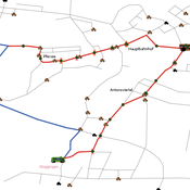
Simulating changing traffic flow caused by new bus route in Augsburg
Eduard | Published Wednesday, August 04, 2021This is a Netlogo model which simulates car and bus/tram traffic in Augsburg, specifically between the districts Stadtbergen, Göggingen and the Königsplatz. People either use their cars or public transport to travel to one of their random destinations (Stadtbergen or Göggingen), performing some activity and then returning to their home. Attributes such as travel and waiting time as well as their happiness upon arriving are stored and have an impact on individuals on whether they would consider changing their mode of transport or not.
Displaying 10 of 393 results for "Tim Gooding" clear search