Our mission is to help computational modelers develop, document, and share their computational models in accordance with community standards and good open science and software engineering practices. Model authors can publish their model source code in the Computational Model Library with narrative documentation as well as metadata that supports open science and emerging norms that facilitate software citation, computational reproducibility / frictionless reuse, and interoperability. Model authors can also request private peer review of their computational models. Models that pass peer review receive a DOI once published.
All users of models published in the library must cite model authors when they use and benefit from their code.
Please check out our model publishing tutorial and feel free to contact us if you have any questions or concerns about publishing your model(s) in the Computational Model Library.
Displaying 10 of 391 results for "Huw Vasey" clear search
LBD Model: Learning-by-doing for sustainable management of renewable resources
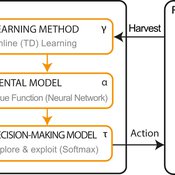
Emilie Lindkvist Örjan Ekeberg Jon Norberg | Published Thursday, March 09, 2017This is a simulation model of an intelligent agent that has the objective to learn sustainable management of a renewable resource, such as a fish stock.
External shocks, agent interactions, and endogenous feedbacks--investigating system resilience with a stylized land use model
Yang Chen | Published Tuesday, March 06, 2018The purpose of the presented ABM is to explore how system resilience is affected by external disturbances and internal dynamics by using the stylized model of an agricultural land use system.
We explore land system resilience with a stylized land use model in which agents’ land use activities are affected by external shocks, agent interactions, and endogenous feedbacks. External shocks are designed as yield loss in crops, which is ubiquitous in almost every land use system where perturbations can occur due to e.g. extreme weather conditions or diseases. Agent interactions are designed as the transfer of buffer capacity from farmers who can and are willing to provide help to other farmers within their social network. For endogenous feedbacks, we consider land use as an economic activity which is regulated by markets — an increase in crop production results in lower price (a negative feedback) and an agglomeration of a land use results in lower production costs for the land use type (a positive feedback).
Peer review model with heterogeneous grade language
Pablo Lucas Thomas Feliciani Ramanathan Moorthy Kalpana Shankar | Published Thursday, May 07, 2020This ABM re-implements and extends the simulation model of peer review described in Squazzoni & Gandelli (Squazzoni & Gandelli, 2013 - doi:10.18564/jasss.2128) (hereafter: ‘SG’). The SG model was originally developed for NetLogo and is also available in CoMSES at this link.
The purpose of the original SG model was to explore how different author and reviewer strategies would impact the outcome of a journal peer review system on an array of dimensions including peer review efficacy, efficiency and equality. In SG, reviewer evaluation consists of a continuous variable in the range [0,1], and this evaluation scale is the same for all reviewers. Our present extension to the SG model allows to explore the consequences of two more realistic assumptions on reviewer evaluation: (1) that the evaluation scale is discrete (e.g. like in a Likert scale); (2) that there may be differences among their interpretation of the grades of the evaluation scale (i.e. that the grade language is heterogeneous).
Peer reviewed Social Consequences of Past Compound Events - Laacher See Eruption
Kevin Su Brennen Bouwmeester | Published Monday, May 17, 2021Resilience of humans in the Upper Paleolithic could provide insights in how to defend against today’s environmental threats. Approximately 13,000 years ago, the Laacher See volcano located in present-day western Germany erupted cataclysmically. Archaeological evidence suggests that this is eruption – potentially against the background of a prolonged cold spell – led to considerable culture change, especially at some distance from the eruption (Riede, 2017). Spatially differentiated and ecologically mediated effects on contemporary social networks as well as social transmission effects mediated by demographic changes in the eruption’s wake have been proposed as factors that together may have led to, in particular, the loss of complex technologies such as the bow-and-arrow (Riede, 2014; Riede, 2009).
This model looks at the impact of the interaction between climate change trajectory and an extreme event, such as the Laacher See eruption, on the generational development of hunter-gatherer bands. Historic data is used to model the distribution and population dynamics of hunter-gatherer bands during these circumstances.
Holmestrand School Model
Jessica Dimka | Published Friday, June 18, 2021 | Last modified Friday, April 29, 2022The Holmestrand model is an epidemiological agent-based model. Its aim is to test hypotheses related to how the social and physical environment of a residential school for children with disabilities might influence the spread of an infectious disease epidemic among students and staff. Annual reports for the Holmestrand School for the Deaf (Norway) are the primary sources of inspiration for the modeled school, with additional insights drawn from other archival records for schools for children with disabilities in early 20th century Norway and data sources for the 1918 influenza pandemic. The model environment consists of a simplified boarding school that includes residential spaces for students and staff, classrooms, a dining room, common room, and an outdoor area. Students and staff engage in activities reflecting hourly schedules suggested by school reports. By default, a random staff member is selected as the first case and is infected with disease. Subsequent transmission is determined by agent movement and interactions between susceptible and infectious pairs.
PaleoscapeABM: coastal occupation and shellfish discard
Claudine Gravel-Miguel | Published Tuesday, February 08, 2022This model builds on the Armature distribution within the PaleoscapeABM model, which is itself a variant of the PaleoscapeABM available here written by Wren and Janssen, and.
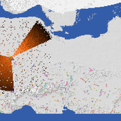
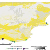
This model aims to explore where and how much shellfish is discarded at coastal and non-coastal locations by daily coastal foraging. We use this model’s output to test the idea that we can confidently use the archaeological record to evaluate the importance of shellfish in prehistoric people’s diets.
The recognition that aquatic adaptations likely had significant impacts on human evolution triggered an explosion of research on that topic. Recognizing coastal foraging in the past relies on the archaeological signature of that behavior. We use this model to explore why some coastal sites are very intensely occupied and see if it is due to the shellfish productivity of the coast.
Peer reviewed The OctoPINTS Model: Compliance and periodic fisheries closures (Beta)
Emilie Lindkvist Maja Schlüter Tim M Daw Elizabeth Drury O'Neill Benedetta Veneroni Jineth Berrío-Martínez | Published Wednesday, April 20, 2022The purpose of the model is to explore how processes associated with compliance across different fishery actors’ social groups interplay with their acceptance of a fishery intervention, herein periodic closures of a small-scale octopus fishery. The model agents, entities and processes are designed based on stylized facts from literature and expert workshops on periodic closures in the Western Indian Ocean region, as well as fieldwork from Zanzibari villages that have implemented periodic octopus closures. The model is designed for scientists and decision-makers that are interested in understanding the complex interplay between fishers from different social groups, herein foot fisher men, foot fisher women and male skin divers or free divers within the periodic closure of an octopus species. Including various actions resulting from the restrictions, that is - opportunities that may be presented from restricting fishing in certain areas and during certain times. We are soon publishing an updated model with individual octopuses and their movement behaviors.
An agent-based model of cultural change for a low-carbon transition
Daniel Torren-Peraire | Published Friday, November 10, 2023An ABM of changes in individuals’ lifestyles which considers their
evolving behavioural choices. Individuals have a set of environmental behavioural traits that spread through a fixed Watts–Strogatz graph via social interactions with their neighbours. These exchanges are mediated by transmission biases informing from whom an individual learns and
how much attention is paid. The influence of individuals on each other is a function of their similarity in environmental identity, where we represent environmental identity computationally by aggregating past agent attitudes towards multiple environmentally related behaviours. To perform a behaviour, agents must both have
a sufficiently positive attitude toward a behaviour and overcome a corresponding threshold. This threshold
structure, where the desire to perform a behaviour does not equal its enactment, allows for a lack of coherence
between attitudes and actual emissions. This leads to a disconnect between what people believe and what
…
Peer reviewed Modelling value change; An exploratory approach
Tristan de Wildt Ibo van de Poel | Published Tuesday, June 20, 2023 | Last modified Tuesday, December 12, 2023This model has been developed together with the publication ‘Modelling Value Change - An Exploratory Approach’
Value change and moral change have increasingly become topics of interest in the philosophical literature. Several theoretical accounts have been proposed. Such accounts are usually based on certain theoretical and conceptual assumptions and their strengths and weaknesses are often hard to determine and compare, also because they are based on limited empirical evidence.
We propose that a step forward can be made with the help of agent-based modelling (ABM). ABM can be used to investigate whether a simulation model based on a specific account of value change can reproduce relevant phenomena. To illustrate this approach, we built a model based on the pragmatist account of value change proposed in van de Poel and Kudina (2022). We show that this model can reproduce four relevant phenomena, namely 1) the inevitability and stability of values, 2) how different societies may react differently to external shocks, 3) moral revolutions, and 4) lock-in.
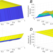
Role of Diversity in Team Performance: the Case of Missing Expertise, an Agent Based Simulations
Tamás Kiss | Published Friday, December 29, 2023This ABM simulates problem solving agents as they work on a set of tasks. Each agent has a trait vector describing their skills. Two agents might form a collaboration if their traits are similar enough. Tasks are defined by a component vector. Agents work on tasks by decreasing tasks’ component vectors towards zero.
The simulation generates agents with given intrapersonal functional diversity (IFD), and dominant function diversity (DFD), and a set of random tasks and evaluates how agents’ traits influence their level of communication and the performance of a team of agents.
Modeling results highlight the importance of the distributions of agents’ properties forming a team, and suggests that for a thorough description of management teams, not only diversity measures based on individual agents, but an aggregate measure is also required.
…
Displaying 10 of 391 results for "Huw Vasey" clear search